Thursday, September 30, 2010

40. Postcard from Germany

Karte 24 von 24 aus dem Postartenbuch - UNTERWEGS


24 kartka z serii pocztówek - "W drodze"
 24 card with a series of postcards - "On the Road"

Regionalbahn (także RegionalBahn, RB, niem. kolej regionalna) - kategoria pociągu Deutsche Bahn, który w Niemczech zastąpił klasyczne pociągi osobowe (Personenzug, P), a także późniejsze bliskobieżne (Nahverkehrszug, N). Regionalbahn obsługuje z reguły wszystkie dworce i przystanki kolejowe na trasie, na której kursuje.

The Regionalbahn (abbreviated RB) is a type of local passenger train (stopping train) in Germany. Regionalbahn trains usually call at all stations on a given line, with the exception of RB trains within S-Bahn networks, these may only call at selected stations. Thus, they rank below the Regional-Express train, which regularly stops only at selected stations on its route. 


Distance: 625 km (388 miles) 
Travel time: 4 days


39. Postcard from Netherlands

Location/Lokalizacja: Region Peloponez, Grecja
Athens - National Arch. Museum,
Mask from the Acropolis of Mycenae


Pocztówka przedstawia maskę Agamemnona.
 The postcard shows the mask of Agamemnon. 

Maska Agamemnona – została odnaleziona przez Heinricha Schliemanna, w jednym z grobów na terenie Myken. Jest to wykonany ze złotej blachy wizerunek mężczyzny z brodą i wąsami. Przedstawione rysy twarzy oddają indywidualny charakter zmarłego. Maska ma wymiary 26 cm (wysokość) i 26,5 cm (szerokość), datowana jest na ok. 1500 p.n.e., czyli jest starsza niż czasy wojny trojańskiej. Obecnie znajduje się w zbiorach Narodowego Muzeum Archeologicznego w Atenach. Jest to najbardziej znane dzieło złotników mykeńskich.

The Mask of Agamemnon is an artifact discovered at Mycenae in 1876 by Heinrich Schliemann. The mask is a gold funeral mask, and was found over the face of a body located in a burial shaft (grave V). Schliemann believed that he had discovered the body of the legendary Greek leader Agamemnon, but modern archaeological research suggests that the mask is from 1550–1500 B.C.E (earlier than the life of Agamemnon, as tradition regards it). The mask is currently displayed in the National Archaeological Museum in Athens. 

Distance: 527 km (327 miles)
Travel time: 5 days

38. Postcard from Russia

Location/Lokalizacja: Czelabińsk, Obwód czelabiński, Rosja
House engineer A. Morozov,
 Chelyabinsk - Russia


Pocztówka przedstawia dom rosyjskiego inżyniera A.Mrorozowa, 
twórcy zawieszenia czołgu T-34.
The postcard shows the house of the Russian engineer A. Mrorozov,
the creator of the tank T-34. 

W Czelabińsku podczas II wojny światowej znajdowało się bardzo dużo fabryk produkujących m.in słynny czołg T-34. W wyniku wielkiej liczby wyprodukowanych przez miasto czołgów, miasto było nazywane Tankogradem. 


Distance: 4,016 km (2,495 miles)
Travel time: 16 days

Monday, September 27, 2010

37. Postcard from U.S.A.

Location/Lokalizacja: Yosemite, Yosemite Natl Pk, Kalifornia 95389, Stany Zjednoczone
Half Dome, Merced River, Winter, Yosemite National Park, California, c. 1938


Piękne góry w Parku Narodowym Yosemitte w Kalifornii.
 Zdjęcie zrobione w 1938 roku. 
Beautiful mountains Yosemitte National Park in California.
Picture made in 1938.

 
Park Narodowy Yosemite - park narodowy położony w USA, w środkowej Kalifornii, na zachodnich zboczach gór Sierra Nevada. W ramach parku leży Yosemite Valley (Dolina Yosemite). Dolina Yosemite była od wieków domem Indian Miwok i Pajutów, którzy żyli tam w spokoju do chwili wybuchu gorączki złota w Kalifornii. Nazwa Yosemite wywodzi się od indiańskiego słowa określającego niedźwiedzia grizzly, będącego plemiennym totemem rdzennych mieszkańców tych ziem.

Yosemite National Park is a United States National Park spanning eastern portions of Tuolumne, Mariposa and Madera counties in east central California, United States. The park covers an area of 761,268 acres (3,080.74 km2) and reaches across the western slopes of the Sierra Nevada mountain chain. Over 3.7 million people visit Yosemite each year:  most spend their time in the seven square miles (18 km2) of Yosemite Valley. Designated a World Heritage Site in 1984, Yosemite is internationally recognized for its spectacular granite cliffs, waterfalls, clear streams, Giant Sequoia groves, and biological diversity.

Distance: 8,476 km (5,267 miles)
Travel time: 6 days

Wednesday, September 22, 2010

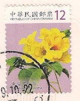
36. Postcard from Taiwan

Location/Lokalizacja: Kaohsiung, Tajwan
Kaohsiung Harbor


Port w Kaohsiung - Tajwan.
Kaohsiung Harbor  - Taiwan.


Kaohsiung to jedno z głównych miast Republiki Chińskiej, położone w południowo-zachodniej części wyspy Tajwan, nad Morzem Południowochińskim. Liczy ono 1,508 mln mieszkańców (2004). Jeden z głównych portów morskich Tajwanu. Drugie co do wielkości miasto kraju. Dawne nazwy: Takao, Takow, Takau.

Kaohsiung is a city located in southwestern Taiwan. It is enclosed by Kaohsiung County, and faces the Taiwan Strait on the west. Kaohsiung, officially named Kaohsiung City, is divided into eleven districts. The city is one of two special municipalities under administration of the Republic of China (also known as Taiwan), which grants it the same status as a province. By the end of 2010 the city will be merged with Kaohsiung County to form a larger municipality.


Distance: 9,968 km (6,194 miles)
Travel time: 20 days

35. Postcard from Ireland


National Photographic Archive, Meeting House Square


Distance: 374 km (232 miles)
Travel time: 2 days

Tuesday, September 21, 2010

34. Postcard from Netherlands

Location/Lokalizacja: 3971 Driebergen, Holandia
Driebergen, Rysenburg 


Distance: 463 km (288 miles)
Travel time: 4 days

33. Postcard from Germany

Johann Christoph Lochner Rheinlaufkarte, 
Nürnberg um 1690 (Ausschnitt), 
Staatsbibliothek zu Berlin Kartenabteilung (Kart. 4010)


Pocztówka przedstawia bieg niemieckiej rzeki Ren  
wraz z największymi miastami leżącymi nad jej brzegiem.
The postcard shows the course of the German Rhine River
with major cities bordering on its shores.

Mam już w podobnej tematyce pocztówkę przedstawiającą Ren współcześnie:
I already have a similar themed postcard which shows the river Rhine today:


Distance: 1,009 km (627 miles)
Travel time: 6 days

32. Postcard from U.S.A.

Location/Lokalizacja: Coast-West, Laguna Beach, Kalifornia 92651, Stany Zjednoczone
California Coast


Pocztówka przedstawia wybrzeze Kalifornii.
The postcard shows the coast of California. 


Wzdłuż wybrzeża Kalifornii koncentruje się osadnictwo ludzkie. Znajdują się tam główne obszary metropolitarne stanu – Los Angeles-Long Beach-Riverside, San Francisco Bay Area i San Diego.

 Counties commonly seen as constituting coastal California.

 
Coastal California refers to the coastal regions of the U.S. state of California. The term is not primarily geographical as it also describes an area distinguished by sociological, economical and political attributes. The coastal regions of California tend to be more politically liberal, affluent and expensive than other regions of the state.


Distance: 8,427 km (5,236 miles)
Travel time: 10 days

Friday, September 17, 2010

31. Postcard from Singapore

Roy Lichtenstein - born 1923,
Bull III, from Bull Profile series.
1973 lithograph, screenprint and linecut 59.6x85.6cm,
Australian National Gallery   

 
Pocztówka przedstawia byka z serii "Byki" namalowanego przez Roya Lichtensteina.
The postcard shows a bull in a series, "Bulls" painted by Roy Lichtenstein. 

Tutaj można obejrzeć całą serię :
Here you can watch a whole series of bulls:


Roy Lichtenstein, 1985
Roy Lichtenstein - (ur. 27 października 1923 w Nowym Jorku, zm. 29 września 1997 w Nowym Jorku) - amerykański malarz, grafik, rzeźbiarz.
Roy Lichtenstein w latach 30. chodził do nowojorskich klubów jazzowych i szkicował portrety muzyków. Był zafascynowany Charlie Parkerem, Johnem Coltrane'em, Milesem Davisem i sam próbował grać na saksofonie. Malarstwo studiował w latach 40. na Ohio State University. Pierwszą wystawę indywidualną miał w 1951 r. w Nowym Jorku. Początkowo malował w stylu abstrakcyjnego ekspresjonizmu, który triumfował wówczas w amerykańskiej sztuce.
Popartowski przełom nastąpił na początku lat 60. Wtedy zaczął malować popularne postaci z kreskówek Disneya. Pierwszy jego popartowski obraz Look Mickey powstał w 1961 r.
Wkrótce jego inspiracją stały się komiksy, reklamy i motywy z malarstwa innych artystów. Pierwsze komiksowe obrazy zaczął wystawiać w nowojorskiej Castelli Gallery, która promowała twórców popartu. W 1965 r. reprezentował USA na Biennale w Wenecji. W drugiej połowie lat 60. zaczął tworzyć obrazy cyklu Brushstrokes parodiujące ekspresyjny abstrakcjonizm. W latach 70. i 80. malował abstrakcyjne cykle Mirrrors. W 1979 r. został członkiem American Academy and Institute of Arts and Letters.
W 1994 r. zaprojektował gigantyczne murale dla nowojorskiej stacji metra Times Square przy 42 Ulicy (zainstalowane w 2002 r.).
Roy Lichtenstein zmarł w 1997 r. w Nowym Jorku. Retrospektywne wystawy miał jeszcze za życia w nowojorskich Muzeum Guggenheima i Museum of Modern Art.

Roy Lichtenstein (October 27, 1923 – September 29, 1997) was a prominent American pop artist. During the 1960s his paintings were exhibited at the Leo Castelli Gallery in New York City and along with Andy Warhol, Jasper Johns, James Rosenquist and others he became a leading figure in the new art movement. His work defined the basic premise of pop art better than any other through parody.  Favoring the old-fashioned comic strip as subject matter, Lichtenstein produced hard-edged, precise compositions that documented while it parodied often in a tongue in cheek humorous manner. His work was heavily influenced by both popular advertising and the comic book style. He himself described pop art as, "not 'American' painting but actually industrial painting".


Distance: 10,926 km (6,789 miles) 
Travel time: 10 days

30. Postcard from China

Location/Lokalizacja: 39号 Xihuamen St, Xicheng, Pekin, Chińska Republika Ludowa
Palacio Imperial de Beijing
a vuelo de pajaro.
Foto de Zhang Zhaoji 


Zakazane Miasto w Chinach.
Forbidden City in China.

Zakazane Miasto dosł. "Starożytny Pałac" – dawny pałac cesarski dynastii Ming i Qing, znajdujący się w centrum Pekinu. Gugong w 1987 został wpisany na listę światowego dziedzictwa UNESCO. Pałac otoczony jest murem obronnym z wieżami przykrytymi charakterystyczną dla całego kompleksu żółtą dachówką, oraz fosą. Kompleks rozplanowano wzdłuż głównej osi północ – południe. Na obszarze o długości 960 m i szerokości 760 m wzniesiono ok. 800 pałaców i wiele mniejszych pawilonów. Pałac i sąsiadujące parki z trzema sztucznymi stawami tworzą całościową, zamkniętą kompozycję.

 The Forbidden City was the Chinese imperial palace from the Ming Dynasty to the end of the Qing Dynasty. It is located in the middle of Beijing, China, and now houses the Palace Museum. For almost five hundred years, it served as the home of emperors and their households, as well as the ceremonial and political centre of Chinese government.
 Built in 1406 to 1420, the complex consists of 980 buildings with 8,707 bays of rooms and covers 720,000 m2 (7,800,000 sq ft). The palace complex exemplifies traditional Chinese palatial architecture, and has influenced cultural and architectural developments in East Asia and elsewhere. The Forbidden City was declared a World Heritage Site in 1987, and is listed by UNESCO as the largest collection of preserved ancient wooden structures in the world.


Distance: 9,275 km (5,763 miles)
Travel time: 50 days

Monday, September 13, 2010

29. Postcard from Germany

Location/Lokalizacja: 83256 Chiemsee, Niemcy
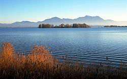
Chiemsee, Bayerisches Meer, grosser See Bayerns, 
80qkm, 74m tief, sehr fischreich, den Alpen noch vorgelagert,
mit den Inseln Frauenchiemsee (Kloster) und Herrenchiemsee (Schloss) 


Pocztówka przedstawia niemieckie jezioro Chiemsee.
The postcard shows the German Lake Chiemsee. 

Chiem, Chiemsee - jezioro w południowo-wschodnich Niemczech na Wyżynie Bawarskiej, u północnego podnóża Alp Salzburskich. Powierzchnia jeziora wynosi 79,9 km², maksymalna głębokość - 73,4 m, długość linii brzegowej - 63,96 km (83 km z wyspami).
Na jeziorze Chiem są 3 wyspy:
Frauenchiemsee (również Fraueninsel) - z żeńskim klasztorem katolickim;
Herrenchiemsee (również Herreninsel) - największa z nich, z parkiem krajobrazowym, w którym stoją 2 zamki: Altes Schloss (Stary Zamek), dawny katolicki klasztor męski, oraz Neues Schloss (Nowy Zamek), zbudowany przez króla Ludwika II Bawarskiego na wzór pałacu w Wersalu;
Krautinsel - niezamieszkana.

Chiemsee (German pronunciation: [ˈkiːmzeː]) is a freshwater lake in Bavaria, Germany, between Rosenheim, Germany, and Salzburg, Austria. It is often called the Bavarian Sea. The rivers Tiroler Achen and Prien flow into the lake; the river Alz, out of it. The Chiemsee is divided into the bigger, north section, in the northeast, called Weitsee, and the Inselsee, in the southwest. The region around the Chiemsee is Chiemgau and is a famous recreation area.


Distance: 605 km (376 miles)
Travel time: 10 days

Saturday, September 11, 2010

28. Postcard from U.S.A.

Frida, Fruits of the Earth, 1938
(Frutos de la tierra)
Oil on Masonite, 40x60cm
Collection of Banco Nacional Mexico, Mexico City 


Obraz namalowany przez meksykańska malarkę Fridę Kahlo.
Painting by Mexican painter Frida Kahlo. 


Frida Kahlo
Frida Kahlo, właśc. Magdalena Carmen Frieda Kahlo y Calderón (ur. 6 lipca 1907, zm. 13 lipca 1954) – meksykańska malarka. Jej prace, często szokujące, obrazują ból i surowe życie kobiet. Wiele z nich (55 spośród 143) to autoportrety, pełne osobistej symboliki, często bazującej na odniesieniach do anatomii. Widoczne są w nich wyraźnie wpływy rdzennej kultury meksykańskiej, przedstawiane w jasnych kolorach, z dodatkiem mieszaniny realizmu i symbolizmu.

Frida Kahlo de Rivera (July 6, 1907 – July 13, 1954; born Magdalena Carmen Frieda Kahlo y Calderón) was a Mexican painter, born in Coyoacán. Perhaps best known for her self-portraits, Kahlo's work is remembered for its "pain and passion", and its intense, vibrant colors. Her work has been celebrated in Mexico as emblematic of national and indigenous tradition, and by feminists for its uncompromising depiction of the female experience and form. 


Distance: 7,869 km (4,890 miles)
Travel time: 26 days

Thursday, September 9, 2010

27. Postcard from Malaysia

Location/Lokalizacja: Selangor, Malezja
The Sultan Sallahuddin Mosque,
Shas Alam, Selangor, Malaysia


Meczet Sułtana Saladyna w Malezji.
Mosque of Sultan Saladin in Malaysia. 


Saladyn
Saladyn, Al-Malik an-Nasir Salah ad-Dunja wa-ad-Din Abu al-Muzzafar Jusuf ibn Ajjub ibn Szazi Al-Kurdi w skrócie Salah ad-Din al-Ajjubi (ur. 1137 lub 1138 w Tikricie w Mezopotamii, zm. 4 marca 1193 w Damaszku) – wódz i polityk muzułmański pochodzenia kurdyjskiego, sułtan Egiptu, władca imperium rozciągającego się od Sudanu po Syrię, od Jemenu przez Półwysep Arabski, północny Irak do wschodniej Turcji (Diyarbakır), uważany za założyciela dynastii Ajjubidów.
Saladyn zasłynął jako zręczny polityk i wódz, a przy tym mecenas sztuki i nauki (zwłaszcza medycyny), człowiek wspaniałomyślny, prawy i rycerski. Jego postać została uwieczniona przez Torquata Tassa w Jerozolimie wyzwolonej. Utworzone przez niego potężne państwo rozpadło się jednak po jego śmierci ponieważ zostało rozdzielone wolą Saladyna pomiędzy jego krewnych. Najstarszy syn, Al-Afdal został emirem Damaszku i rządził południową Syrią. Az-Zahir otrzymał natomiast Aleppo i północną Syrię. Kolejny syn Al-Aziz otrzymał Egipt, natomiast brat Saladyna Al-Adil rządził w Mezopotamii.


 Ṣalāḥ ad-Dīn Yūsuf ibn Ayyūb (Arabic: صلاح الدين يوسف بن أيوب‎, Ṣalāḥ al-Dīn Yūsuf ibn Ayyūb, Kurdish: سه‌لاحه‌دین ئه‌یوبی, Selah'edînê Eyubî) (c. 1138 – March 4, 1193), better known in the Western world as Saladin, was a Kurdish Muslim, who became the first Ayyubid Sultan of Egypt and Syria. He led Islamic opposition to the Franks and other European Crusaders in the Levant. At the height of his power, he ruled over Egypt, Syria, Mesopotamia, Hejaz, and Yemen. He led the Muslims against the Crusaders and eventually recaptured Palestine from the Crusader Kingdom of Jerusalem after his victory in the Battle of Hattin. As such, he is a notable figure in Kurdish, Arab, and Muslim culture. Saladin was a strict adherent of Sunni Islam and a mystical disciple of the Qadiri Sufi order. His chivalrous behavior was noted by Christian chroniclers, especially in the accounts of the siege of Kerak in Moab, and despite being the nemesis of the Crusaders he won the respect of many of them, including Richard the Lionheart; rather than becoming a hated figure in Europe, he became a celebrated example of the principles of chivalry. 

Distance: 10,617 km (6,597 miles)
Travel time: 20 days

Tuesday, September 7, 2010

26. Postcard from Spain

Location/Lokalizacja: 31200 Estella, Hiszpania
Iglesia de San Miguel, siglos XII-XIV 


Kościół św. Michała w hiszpańskim mieście Estella. 
Church of Sts. Michael in the Spanish city of Estella. 

 Herb Estelli
Estella (w jęz. baskijskim Lizarra) - miasto w północnej Hiszpanii w prowincji Nawarra. W średniowieczu było ważnym przystankiem na szlaku pielgrzymek do Santiago de Compostela oraz siedzibą dworu Królestwa Nawarry. W XIX wieku Estella była główną twierdza karlistów. Ośrodek handlu i turystyki górskiej.

Zabytki to:
  • XII-wieczny kościół San Pedro de la Rúa, którego portal zawiera wpływy stylu mudejar;
  • Romański pałac Palacio de los Reyes de Navarra z ekspozycja dzieł sztuki Nawarry;
  • Kościół San Juan Baptista;
  • Kościół San Migule - widoczny na pocztówce.

Estella (Spanish) or Lizarra (Basque) is a town located in the autonomous community of Navarre, in northern Spain. It lies south west of Pamplona, close to the border with La Rioja and Álava.
The town was founded in 1090 when the place, lying by the fortified settlement of Lizarra, was granted a charter by the Pamplonese king Sancho Ramirez. The town became a landmark in the Way of St. James pilgrimage route to Santiago de Compostela, thriving on the privileged location and the melting pot of Francos called in by Navarrese kings (mainly Occitans from Auvergne and Limousin), Jews and the original Navarrese inhabitants. The wealth resulted in a development of Romanesque architecture, well represented in the town: Church of San Pedro de la Rúa, Palacio de los Reyes de Navarra, Church of San Miguel, among others.


Distance: 1,067 km (663 miles)
Travel time: 7 days

Monday, September 6, 2010

25. Postcard from Croatia

Exposition Leonard de Vinci, I'inventeur au Vieil Arsenal de la Fondation Pierre Gianadda
Autoportrait, vers 1516
Sanguine, 333x213mm
Bibloteca Reale, Turin (1571r) 

 
Autoportret Leonarda da Vinci.
Self-portrait of Leonardo da Vinci. 

Rysunek stworzony w 1513 r. przez włoskiego artystę renesansowego, Leonarda da Vinci.
Nie ma całkowitej pewności co do autorstwa Leonarda. 
Niewykluczone, że jest to falsyfikat z XIX w.

Leonardo da Vinci, właściwie Leonardo di ser Piero da Vinci (ur. 15 kwietnia 1452 r. w Anchiano niedaleko Vinci we Włoszech, zm. 2 maja 1519 r. w Clos Lucé we Francji) – włoski renesansowy malarz, architekt, filozof, muzyk, poeta, odkrywca, matematyk, mechanik, anatom, wynalazca, geolog.
 W rozumieniu współczesnym nie miał nazwiska, człon "da Vinci" oznacza bowiem "z miasta Vinci". Jego pełne nazwisko, nadane mu przy narodzinach, to "Leonardo di ser Piero da Vinci", czyli "Leonardo, syn ser Piera z miasta Vinci".
Leonardo często był opisywany jako archetyp "człowieka renesansu", którego wydawałoby się niespożytej ciekawości dorównywała tylko siła jego kreatywności. Szeroko uważa się go za jednego z największych malarzy wszech czasów i prawdopodobnie najbardziej wszechstronnie utalentowaną osobę w historii.

It is believed that Leonardo da Vinci drew a self-portrait in red chalk at about the age of 60. The portrait has been extensively reproduced and has become an iconic representation of Leonardo as polymath or "Renaissance Man". Yet Leonardo appears to have drawn himself older than his age, and there is a sense of solemnness or disillusionment about him, especially around the mouth: at this time his career was largely behind him, and artistic fashion was beginning to leave him behind.
The work is far from universally accepted as a self-portrait. The idea that the drawing is a self-portrait did not appear until the 19th century. Frank Zöllner's Leonardo da Vinci (2000, Taschen) notes in its front matter, "This red chalk drawing has largely determined our idea of Leonardo's appearance for it was long taken to be his only authentic self-portrait. Nowadays it is thought to be a fake, or at best a copy."
If it is authentic, it is generally thought that this self-portrait is the only formal one executed by Leonardo. In the case of some other portraits depicting him, it is not certain whether they are by his hand. Leonardo did include himself subtly in works not intended as portraits, such as his much earlier Adoration of the Magi; critics suspect that the lower right shepherd in this painting represents Leonardo. In mathematician Luca Pacioli's De divina proportione, which Leonardo illustrated, the artist may also have included a self-portrait.
The drawing is housed at the Royal Library (Biblioteca Reale) in Turin, Italy, and is not generally viewable by the public due to its fragility and poor condition. The paper has brownish "fox marks" caused by the accumulation of iron salts due to moisture.

Distance: 1,402 km (871 miles)
Travel time: 17 days

Friday, September 3, 2010

24. Postcard from Russia

Henri Matisse. 1869-1954. The Artist's Family
1911. Oil on canvas. 143x194cm 


Obraz francuskiego malarza Henri Matissa przedstawiający jego rodzinę.
 Picture of Henri Matisse French painter showing his family. 

 Identyczną pocztówkę dostałam z Finlandii:
 I got the same postcard from Finland: 
  http://pytia100.blogspot.com/2010/07/28-jul-2010-my-todays-postcard.html 


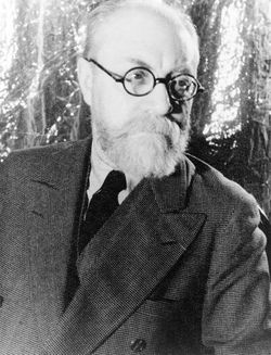
Henri Matisse 20 Maja 1933
Henri Matisse (ur. 31 grudnia 1869 w Le Cateau-Cambrésis w Pikardii, zm. 3 listopada 1954 w Nicei) – francuski malarz uważany za najsłynniejszego fowistę.
Początkowo nie myślał o poświęceniu się sztuce, sposobiąc się do zawodu prawnika. Jednak już w wieku 24 lat rozpoczął naukę malarstwa w paryskiej Szkole Sztuk Pięknych. Uczeń Gustave'a Moreau, początkowo tworzył pod wpływem impresjonistów oraz sztuki japońskiej. W 1905 wystawił swoje prace w "Salonie Jesiennym". Wykształcił wkrótce własny styl. Sławę osiągnął już za swego życia. Matisse zapełniał swoje płótna plamami żywych, świetlistych, zwykle silnie kontrastowych barw, które częstokroć, w trosce czytelności obrazu, obwodził delikatnym konturem.
Po operacji onkologicznej utracił sprawność fizyczną i poruszał się na wózku inwalidzkim (nie mógł pracować przy sztalugach) – zmienił się wtedy profil jego twórczości – tworzył odtąd papierowe kolaże. Henri Matisse był rywalem Pabla Picassa.


 Henri Matisse (French pronunciation: [ɑ̃ʁi matis]; 31 December 1869 – 3 November 1954) was a French artist, known for his use of colour and his fluid and original draughtsmanship. He was a draughtsman, printmaker, and sculptor, but is known primarily as a painter. Matisse is commonly regarded, along with Picasso and Marcel Duchamp, as one of the three artists who helped to define the revolutionary developments in the plastic arts in the opening decades of 20th century, responsible for significant developments in painting and sculpture. Although he was initially labelled a Fauve (wild beast), by the 1920s he was increasingly hailed as an upholder of the classical tradition in French painting. His mastery of the expressive language of colour and drawing, displayed in a body of work spanning over a half-century, won him recognition as a leading figure in modern art.


 Distance: 2,119 km
Travel time: 14 days

23. Postcard from Finland

Rannalla, Henri-Clairy Hembert on maalannut alkuperaisen taulun jalalla


Obraz Henriego-Clairy Hemberta pt: Rannalla.
Jedna z moich ulubionych pocztówek. 

 Picture of Henri-Clairy Hembert "Rannalla".
One of my favorite postcards.

Distance: 2,003 km (1,245 miles)
Travel time: 8 days

22. Postcard from Netherlands

Hollands Glorie 1


Distance: 550 km (342 miles)
Travel time: 10 days

21. Postcard from Romania

Location/Lokalizacja: Orszowa, Rumunia
Manastiera Sfanta Ana,
Orsova, jud. Mehendinti, Romania


Pocztówka przedstawia kościół św. Anny w Orszowie (Romunia).
  The postcard shows the church. Anne in Orsova (Romania). 

Herb Orszowy
Orszowa (także: Orszawa, dawniej Orschawa; rum. Orşova, węg. Orsova, serb. Rušava) – miasto w Rumunii nad Dunajem, w okręgu Mehedinţi.
Miasto wspomniane było pod łacińską nazwą Ursoua w roku 1150.
W okresie panowania rzymskiego położone było w historycznej krainie zwanej Dacją, a następnie Banatem. Po wyparciu przez wojska węgierskie tatarskich Połowców weszło w skład Królestwa Węgier. W okresie wojen z Turcją w Orszowie w roku 1444 przebywał król Polski i Węgier Władysław III Warneńczyk. W roku 1657 Orszowa weszła w skład Monarchii Habsburskiej. Od 1552 do 1718 należała do Turcji. Do roku 1918 była w składzie Austro-Węgier. 

Orşova (German: Orschowa, Hungarian: Orsova, Serbian: Оршава, Bulgarian: Орсово, Polish: Orszawa, Czech: Oršava, Turkish: Adakale) is a port city on the Danube river in southwestern Romania's Mehedinţi County. It is one of four localities in the county located in the Banat historical region. It is situated just above the Iron Gates, on the spot where the Cerna River meets the Danube.

Distance: 1,947 km (1,210 miles)
Travel time: 11 days